In Northern California, the Granddaddy Lake
- Share via
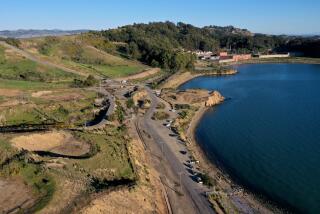
“Wow!” may be the most common response of hikers who gaze down upon giant Clear Lake from the top of Dorn Nature Trail.
Clear Lake is the largest lake entirely within California. (Tahoe is larger but is partly in Nevada.)
Not only is Clear Lake huge, it’s positively ancient. Geologists estimate it’s 2.5 million years old; some claim it’s the oldest lake in North America. At the very least, it’s considerably older than such 5,000-year-old “infants” as lakes Tahoe and Superior.
The lake is in southern Lake County, in that “other” wine country immediately north of Napa and Sonoma counties, and about 100 miles north of San Francisco. Around the lake are mountains, and beyond the mountains a plain of vineyards, walnut groves and, as locals boast, “the world’s largest Bartlett pear-growing area.”
At its worst, the lake is ringed with resorts, some quite tacky. The north shore hamlets of Nice and Lucerne borrow only the names of their European counterparts.
Clear Lake State Park offers much-needed public access to the lake and preserves about two miles of lakeshore. Situated on the southern shore, the state park includes some terrific campsites at Kelsey Creek Campground. Dorn Nature Trail samples the slopes above Clear Lake and offers fine Lake County vistas.
Directions to trail head: From California 29 in Kelseyville (just south of Lakeport) turn east on Soda Bay Road and follow the signs to Clear Lake State Park. Leave your car in the day-use parking area near the Visitor Center.
The hike: From the Visitor Center, walk back up the day-use access road to the main park road; here you’ll see signed Dorn Nature Trail. The path joining Dorn Nature Trail from the left is the return leg of the loop.
The path ascends into a woodland of California buckeye and valley oak, switch-backs a bit, and soon serves up the first view of the lake.
A quarter-mile climb brings you to the crest of a minor ridge and a junction with a side trail splitting to the right and leading to Upper Bayview Campground. Stay left and continue on Dorn Trail to an overlook.
Three-quarters of a mile out, about halfway through this walk, the path descends and passes a right-forking trail leading to Lower Bayview Campground.
The descent continues over ferny slopes, contours west, then drops to the park road back at the trail head.
*
One of the most populous American Indian groups in prehistoric California, the Pomo, occupied the Anderson Marsh area on Clear Lake’s southeastern shore as long as 10,000 years ago.
Pomo elders construct a traditional village in Anderson Marsh State Historic Park every year. This village of tule huts also serves as a picnic area, an odd, but somehow fitting mixture of the ancient and modern uses of nature.
Two trails lead along the wetter parts of the park--Cache Creek and Marsh. Two other trails--Ridge (which ascends through an oak woodland) and Anderson Flats (which crosses a grassland) explore drier parts of the park. It’s less than a mile’s walk to the reconstructed Pomo village.
Directions to trail head: Anderson Marsh Park is located just off California 53 between the hamlet of Lower Lake and the town of Clear Lake. The park is a short distance north of Lower Lake and the junction of highways 29 and 53.
The hike: Walk west through the meadow along the park’s southern boundary fence. The flat path through the Anderson pasture forks: Anderson Flats Trail (a possible return route) is on your right, but bear left, angling with the fence line to what is (sometimes) the site of a reconstructed Pomo village.
The path ascends through a blue oak woodland, passes a junction with Ridge Trail, then turns left to an interpretive display about bald eagles that drop in on the marsh during winter months.
(Those seeking a close look at the marsh will join McVicar Trail that heads into the Audubon Sanctuary. Hope you brought your binoculars to spot the abundant bird life!)
Otherwise, join Marsh Trail, which offers a good view of the marsh as it descends from the oak woodland toward the marsh. A bit more than a mile from the start, you’ll top a low ridge and meet up with Cache Creek Trail. Atop this ridge, amid plenty of poison oak, are Pomo grinding holes and petroglyphs. For a moment you can imagine Pomo life, until you look into the distance and spot the vacation homes fringing the marsh.
The quick way back--a straight line across the meadow--is Anderson Flats Trail. A more interesting return is along Cache Creek, which meanders across meadows, then turns east to follow the cottonwood-lined creek. The patch nears the highway, then veers right and returns to the ranch house.
Clear Lake Clear lake State park, Anderson Marsh State Park
WHERE: Clear Lake State park, Anderson Marsh State Historic Park.
TERRAIN: Oak dotted slopes and grasslands, tule marsh.
HIGHLIGHTS: California’s largest natural lake.
DISTANCE: Clear Lake: 1 1/2-mile loop Angerson Marsh: 2-3 Miles round trip.
DEGREE OF DIFFICULTY: Easy.
FOR MORE INFORMATION:
Clear Lake State park, 5300 Soda Bay Road, Kelseyville, Calif. 95451; (707) 279-4293: Angerson Marsh State Historic Park, 8825 N. Highway 53, Lower Lake , Calif. 95457; (707) 994-0688.
More to Read
Sign up for The Wild
We’ll help you find the best places to hike, bike and run, as well as the perfect silent spots for meditation and yoga.
You may occasionally receive promotional content from the Los Angeles Times.


