Spring rain and snow fell short of miraculous for most of California
- Share via
As April draws to a close and the winter season goes into the record books, the prospects of a rainfall recovery have all but vanished for most of California.
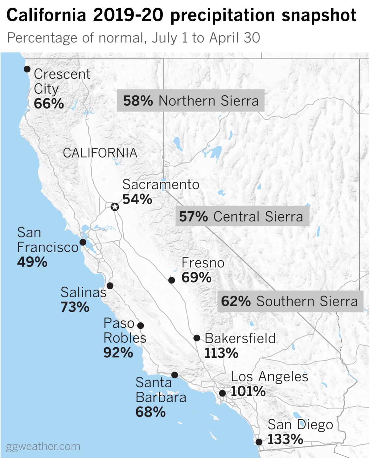
Southern California benefited from late-season storms, and is at or above normal for the season at many locations, but the rest of the state suffers a deficit in spite of hopes for a “March Miracle.” Northern California precipitation stands at between 50% and 60% of normal, and Central California is mostly about 60% to 70% of normal for the season.
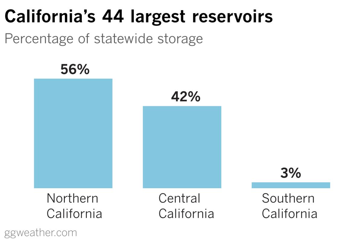
The problem with rainfall being more abundant in the south, as Jan Null of Golden Gate Weather Services points out, is that only about 3% of the state’s reservoir capacity is south of the Tehachapis. The biggest reservoirs are all in Northern and Central California.
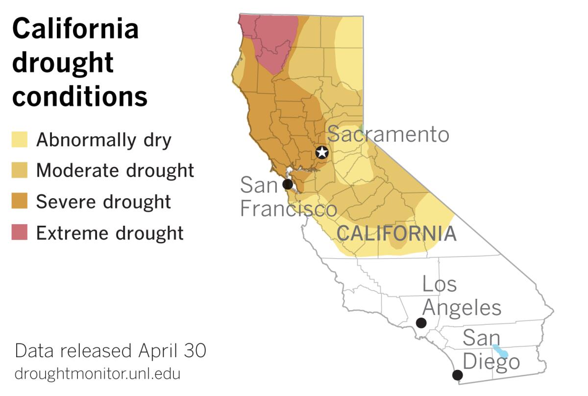
As a result, the latest Drought Monitor data released on Thursday show that moderate drought has continued to expand in Northern California. The portion of the state considered to be in moderate drought increased from 16.1% to almost 22%, spreading into western Modoc and Lassen counties and across Plumas, Sierra, Nevada and northern Placer counties eastward to the Nevada border.
This area of the mountains is part of the crucial Northern Sierra 8-Station Index, an average of eight precipitation measuring sites that provide a representative sample of the northern Sierra’s major watersheds. These watersheds include the Sacramento, Feather, Yuba and American rivers. These rivers flow into some of California’s biggest reservoirs, providing a large portion of the state’s water supply.
The Northern Sierra 8-Station Index stands at 58% of normal for the season.
Within this area, just southeast of Lake Tahoe along U.S. Highway 50, is Phillips Station, where the state Department of Water Resources conducted the fifth and final snow survey of the water year. The snowpack measured 1.5 inches deep and had a snow water equivalent of 0.5 inches, or just 3% of the May average for that location.
The Drought Monitor shows that the portions of the state in severe and extreme drought remain unchanged, at about 14.9% and 4.7% respectively. The 41.8% of the state not in drought is also unchanged, and this is all in the southern part of the state where rainfall was augmented by wintry storms in March and early April.
Cities such as San Francisco and Sacramento finish April with about half their normal rainfall. Both are in the area of severe drought. Crescent City, with 66% of normal rainfall for the season, is in the area of northwest California classified as being in extreme drought.
The extreme drought area laps into a narrow sliver of southwestern Oregon. Severe drought covers much of western Oregon, and the Drought Monitor reports that precipitation for the water year ranks as the third-driest in the Portland station’s 89-year period of record.
More to Read
Sign up for Essential California
The most important California stories and recommendations in your inbox every morning.
You may occasionally receive promotional content from the Los Angeles Times.

