Column: How Waze and Google Maps turned an Encino neighborhood into a speedway

- Share via
Pam Sobo is having trouble getting out of her driveway in the hills of Encino.
The problem is not mechanical. Her car is fine.
The problem is the navigation apps that have disrupted neighborhood traffic patterns and turned her once-quiet street into a speedway.
“Please help me and others who live on Ballina Canyon Road,” Sobo wrote after she saw my column on diverted drivers spinning out on the crazy Baxter Street incline in Echo Park. “Waze has killed our street. Ruined our neighborhood.”
There’s a stop sign in front of Sobo’s house. In the morning, cars pull to a halt (or not) and then hit the gas to blast up the hill.
Everybody is in a hurry in Los Angeles. We’ll do anything to shave 10 seconds off a commute, unwilling to change our evil ways (which has more than one spelling).
“This is nothing,” Sobo told me Tuesday morning as we stood in front of her house and watched the unchained caravan of cars roar by, the racket pounding through the canyon. “This is pretty light.”
It didn’t look light to me. The worst of the morning commute was over, but in a short time, I saw enough cars to fill the parking lot at Dodger Stadium.
Janet Mintz, a neighbor, dropped by to back up Sobo.
“It’s terrible and getting worse,” she confirmed.
The problem, they say, is that drivers who were headed south in the morning, over the hill and into the basin, used to travel up Hayvenhurst Avenue in the days before everyone had a shortcut at their fingertip. That got them to Mulholland Drive and Sepulveda Boulevard.
But now they are being told by Waze, Google Maps and other navigation apps to go on Ballina Canyon to Westfall Drive and Royal Hills Drive, then cut west. For the evening rush, those same drivers come barrelling down the same route, headed in the opposite direction.
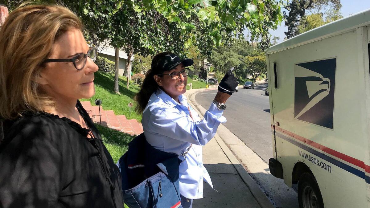
“It’s dangerous and I mean really, really bad,” said mail carrier Veronica Solis, who has worked in the neighborhood for 28 years and watched it go from undiscovered to over-burdened.
“It used to take me 10 minutes to deliver this street, and now it takes me 20 minutes because of all the traffic,” she said. “It’s changed completely.”
Sobo and I bumped into Solis as she delivered mail to the home of Tiffany Grana, who just sold her place.
“I don’t want to say traffic was completely the reason, but that was part of it,” said Grana. “Traffic was a little bit bad when we moved in here in 2002, but now it’s ridiculous. Absolutely and completely ridiculous.”
It’s not just the volume of cars that bothers her, she said, but the speeding.
“If my kid’s ball rolled into the street,” she said, “he would probably die.”
In fact, Sobo and I saw one driver zip into warp speed to pass another car. And by the way, is it just my imagination, or are there more insane drivers on the freeways these days, tailgating as if they’re trying to climb into your trunk and swerving around cars like they’re in the Indy 500?
In Encino, it’s not just the residents of Ballina Canyon Road who’ve grown weary of traffic that has killed off the tranquility that attracted them to the neighborhood in the first place. Social media has plenty of posts from exasperated residents of nearby streets. Between the digital diversions and a spate of break-ins, lots of people feel like they’re under siege.
As I said last month, there’s nothing new about the app-driven problem except that it’s not getting any better, and more residents seem to be demanding that something be done about it.
What happened on Baxter Street, though, after City Hall got involved and proposed its “mitigation measures,” was a reminder that when it comes to traffic, one person’s relief may cause another person’s misery.
The cut-through relief plan for Baxter, which rises and falls on a 33% grade, was to chop it into one-way sections heading west at one point and east at another. One-way conversions on nearby streets are also part of the plan, along with more stop signs.
“I don’t know why the people who live here have to suffer for the *&@)! commuters who don’t want to sit in traffic on the 2 Fwy,” wrote Diana Wagman, who lives near Baxter and predicts mayhem.
“This is a classic case of the cure being worse than the disease. It’s ATROCIOUS for anyone who lives near Baxter,” wrote Tod Mesirow, who lives in the neighborhood.
I asked Mesirow if he understood why the city and the app companies couldn’t have instead agreed to remove Baxter Street as an option, given the outrageous incline and the number of accidents.
“That is the question that no one will answer,” he said.
When I asked Waze representatives last month about removing Baxter from its app, I was told “the city has placed a public road there, which means it should be considered usable…. Should local government choose to make a change, we will of course update our maps.”
City Councilman Paul Krekorian made what I thought was a great point last month when he told me the use of apps to “save 90 seconds of travel time not only is destroying the quality of life in Los Angeles, but also endangering public safety.” The city has a data-sharing relationship with the app companies, Krekorian said. Among his questions for the transportation department:
“What efforts has the city made to engage mapping app makers to address neighborhood concerns and what has been the response from that engagement?”
A transportation spokesman told me the report Krekorian requested has not been completed.
In theory, the traffic that has radically changed Sobo’s Encino neighborhood, and countless others, should mean that we’re benefiting from lighter traffic on highways and thoroughfares.
But it sure doesn’t feel like it.
Instead, it feels like our addiction to cars and apps is taking its toll. And between here and where we’re going, there are no shortcuts.
Get more of Steve Lopez’s work and follow him on Twitter @LATstevelopez
More to Read
Sign up for Essential California
The most important California stories and recommendations in your inbox every morning.
You may occasionally receive promotional content from the Los Angeles Times.


